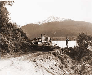
Haines Highway construction, 1943.
The Haines “Cut-Off” Road, approximately 160 miles of spectacular beauty, connects the Alaska Highway at Haines Junction with the Alaskan seaport of Haines.
It all began centuries ago with the Chilkat people, members of the coastal Tlingit Indians. From the ancient village of Klukwan (23 miles north of Haines) and other settlements in the vicinity, a well-established trail developed north to the Interior. This route served as access for a thriving trading business with other Interior tribes. It followed the Chilkat and Klehini Rivers through Rainy Hollow, up over the Chilkat Pass, across Stonehouse Creek, down the Nadahini and Mansfield Creeks and up the Blanchard River into the Yukon Territory. The trail led along the Blanchard and Tatshenshini Rivers through what is now known as the Dalton Post area and on to Klukshu Lake. From here the trail zigzagged along the east side of Dezadeash Lake on to Champagne via the Dezadeash River.
As long ago as 1882 one Arthur Krause of the Bremen Geographical Society explored this route and made a remarkably accurate map which was later incorporated in an 1887 paper called Dawson’s Report.
In the early 1890s, Jack Dalton, an adventurer and entrepreneur of controversial repute improved on a trail system (known as the Dalton Trail) from Pyramid Harbor, Alaska, on the Chilkat Inlet to the confluence of the Nordendskiold and Lewis (Yukon) Rivers well within the Yukon. This trail, developed well before the Klondike gold strike, consisted primarily of existing Indian trails. Some years earlier, Dalton had built trading posts at Pleasant Camp (AK/Canadian border) and at Dalton Post, on the Tatshenshini (now accessed at Mile 104). In spite of some confrontations, Dalton operated pack train and ox and wagon drayage and drove cattle over the trail with a certain amount of success and no doubt a share of hardship.
From 1897 to 1899 hoards of optimistic gold seekers used the then well-beaten trail on their trek north. Locally, in the summer of 1898, placer gold was discovered on Porcupine Creek, Alaska. By 1899, a wagon road extended from Pyramid Harbor via Porcupine, along the south side of the Klehini to Pleasant Camp. By 1914, a good wagon road reached from Haines along the south side of the Klehini to the international boundary at Pleasant Camp then along the northern side of the river to Rainy Hollow. A series of mining discoveries and related activities kept the lower Dalton Trail active through the years following its establishment. A wagon road from Pleasant Camp to Rainy Hollow was built by the B.C. provincial government in 1908/1909 at which time copper properties near Copper Butte were being developed. Copper was also discovered in the Three Guardsmen (Mt. Glave) region in 1909.
In 1911, 30 tons of ore yielding 1,657 oz. of silver and 19,161 lbs. of copper were shipped from the mine. During this time, Alaska rebuilt the road from Haines to Wells, constructed a bridge across the Chilkat River and extended the road along the northern side of the Klehini toward Pleasant Camp. Further up the route into the Yukon, gold was discovered at Squaw Creek in 1927 by Paddy Duncan, a Native from Klukshu. During the 1930s, 20 to 45 miners worked each summer on this creek. A large nugget, over 46 oz., was taken on the creek in 1937.
The threat of war on this continent was a reality in 1942. Upon completion of the pioneer version of the Alaska Highway, the U.S. Government decided that an alternate access to the highway should be provided in case the White Pass Railway was blocked. This would provide another supply route and a possibly important evacuation exit to the coast if needed. As a result, the Haines road was built in 1943 by the U.S. Army at a cost of $13 million. The general route of the Dalton Trail was followed as far as Klukshu Lake. From there the highway took the western shore of Dezadeash Lake.
Haines Highway construction, 1943.
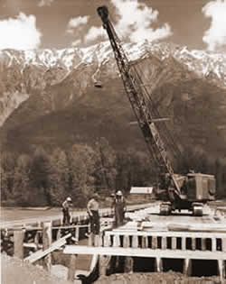
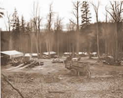
Construction took place from January to December of 1943. One major construction camp was set up at the Takhane River, Mile 103, present site of Million Dollar Falls Campground. Another was located at the south end of Dezadeash Lake, Mile 125, later to be known first as Beloud Post and later as Dezadeash Lodge. Upon completion of the highway, salvaged building materials from these camps became prime sources of local building materials for both private homes and highway lodges.
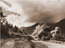
Blasting during Haines Highway construction, 1943.
In the post-war era the Haines Road served well as an extension of the Alaska Marine Highway System to northern Alaska. It first opened on a year-round basis in 1963. Considering the severity of winter storms, maintenance of the highway was and still is a challenge by any man’s measure. With extremely high wind chill factors coupled with drifting snow and poor visibility, the winding route can be unforgiving. Its maintenance is shared by AK Department of Transportation and Canadian Territorial camps at Mule Creek (75 mi.), Blanchard River (94 mi.) and Haines Junction. During the sixties and early seventies a radio check system operated which carefully monitored each passing vehicle. Until the early sixties the passage was seasonal at best. The route was often blocked by a mudslide near the border. This problem persisted for some forty years until the slide area was by-passed by new construction in 1983. The following excerpt from a 1948 B.C. Dept. of Mines Bulletin provides as interesting insight into transportation conditions in early years.
 Haines Highway construction, 1943. |
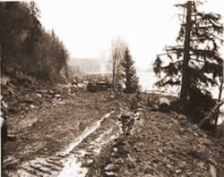
 Haines Highway construction camp, 1943. |
“In the first part of the 1946 season the road was not passable with safety because of serious flood damage at Stanley Creek, minor damage at several other creeks and because of a large slide near Pleasant Camp. A road crew of the Canadian Army had the road in repair by the middle of the summer and continued improving it until the end of autumn. Late in the summer, busses started running on a weekly schedule between Whitehorse and Haines and an officer of the Canadian Customs was stationed at Pleasant Camp. During the summer of 1945 and 1946 the freight rates on camping equipment were as follows: Vancouver to Whitehorse, $99 per ton. The freight rates on machinery were: Vancouver to Skagway, $15 per ton; Vancouver to Whitehorse, $71 per ton. Trucks carrying freight from Whitehorse along the Alaska Highway charge 10 cents per ton-mile. Packhorses may be hired from S. Chambers at Champagne, 60 miles west of Whitehorse. The horses may be transported by truck into the area or may travel on foot over a more direct route by way of Dezadeash River, Dezadeash Lake, and Klukshu. Provisions and general supplies are obtainable at Whitehorse, Champagne, and Haines.”
In 1954 the Haines Road once again became the object of an American military-related project when its route was paralleled by a Haines to Fairbanks pipeline. The line included associated pump stations at Mile 48 and Mile 94. A Vancouver joint venture organization built the 8″ line in 1954-1956 under contract with the U.S. Corp. of Engineers and under the direction and supervision of Fluor Corp., a Los Angeles based consulting firm. The line transported many fuels north including aviation, automobile, diesel and jet, until operations ceased in 1970.
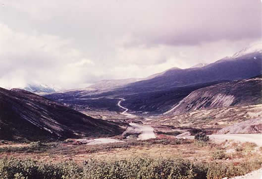
Chilkat Pass in summer, 1975.
Commensurate with an American desire to have an all-paved highway to Alaska, the road underwent major reconstruction begining in 1979 and continued through the 1990s funded by the United States. The “Shakwak” Program, named after the valley in which it lies, updated the entire route from Pleasant Camp at the Alaska B.C. border to Beaver Creek at the Yukon-Alaska border. A testimony to the quality of Public Works Engineering and quality control, the new sections, often in difficult mountain terrain, are second to none in excellence.
Haines Highway Declared National Scenic Byway
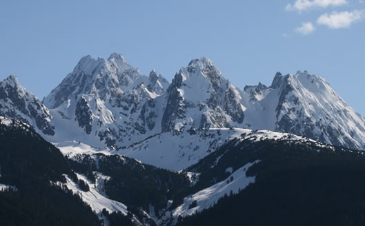
A view of the “Cathedral Peaks” as seen from along the Haines Highway, 2011.
In October 2009, the Haines Highway received national recognition as one of America’s new National Scenic Byway.
The National Scenic Byways program was created by Congress in 1991. Under the National Scenic Byways Program, the U.S. Secretary of Transportation recognizes certain roads as National Scenic Byways or All-American Roads for their outstanding qualities. “America’s Byways are the roads to the heart and soul of America,” said Secretary Mineta. “Byways help create a sense of pride in America. They connect us to this country’s beauty, history and culture.”
The Haines Highway is part of the Golden Circle Route, which continues from Haines Junction to Whitehorse and back down to Skagway, and includes the ferry trip between Skagway and Haines.
Merle Lien, Haines Junction, 1987
Updated by Blythe Carter, 2013
Condensed from Merle Lien’s two-part series, “History of the Haines Road” printed in Aug. 19 & 26, 1987 issues of The Yukon News.
Bibliography:
Merle Lien, “History of the Haines Road” printed in Aug. 19 & 26, 1987 issues of The Yukon News.
Capital City Weekly, “Haines Highway receives National Scenic Byway designation” Wednesday, October 28, 2009.
haines.ak.us, web article: “Scenic Byway”